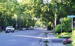
 Another one of the tree-lined streets in Davis
B Street is a street that runs north-south between A Street and C Street. It runs from 1st Street, bending at 6th Street, and running up to East 14th Street, where it ends right in front of the Veterans Memorial Center.
B Street was once known as Ash Street.
Along B Street, you can find:
- 200 B Street
- Acadian Properties 140 B Street
- Aileen Johnson Bench
- Best Western University Lodge 123 B Street
- Black Bear Diner
- Central Park
- Central Park Gardens
- Ciocolat
- City Hall
- Civic Center Pool
- Davis Lutheran Church / Crossings Alternative Worship
- Davis Townhouse Apartments 413 B Street
- Dead Zone Novelties 140 B Street, Suite 2
- Delta of Venus 122 B Street
- DJUSD
- DJUSD Children's Center
- Fast and Easy Mart 140 B Street
- The Inconvenient Store 140 B Street, Suite 4
- Parkside Plaza
- J. Alex Tomaich, DDS MD
- King High School
- St. James Catholic Church
- St. James Catholic School
- Third and B
- UPS Store 140 B Street #5
- USE Credit Union
- Veterans Memorial Center
The neighborhood on the West side of the B and 3rd street is being revisioned by the City. There's some "green construction" going on across from Central Park just north of Ciocolat—houses that replace the houses that were moved to 3rd/J and repurposed to cooperative housing. Signage credits the developer and gives the project a name.
Why isn't B Street straight?
You may have noticed that B Street is bent slightly at 6th Street, while surrounding lettered streets in old North Davis are straight. This goes back to the original orientation of the downtown core.
The original 1868 grid of Davis was laid out parallel and perpendicular to the railroad tracks, but the railroad does not travel exactly east/west. It is rotated about 13° counter-clockwise. When the Bowers Addition was being mapped out, they opted to continue the railroad orientation of the streets as they built out to the north. But this was in conflict with county-level standard of having a true north-south-east-west street orientation.
At B Street, which was the western boundary of the Bowers Addition, they decided to bend the street back toward true north as an accommodation to the Yolo County Road planners. So at 6th Street, B Street bends back 8° to the east. The full 13° correction would not have been possible without eliminating some of the home lots toward 7th Street—thus the compromise.
Source: Old North Davis: Guide to Walking a Traditional Neighborhood, by John Lofland


