Shingle Mill Creek is a name shared by two streams. The stream that enters Corralitos Creek is listed as Shingle Mill Gulch by the USGS maps.
Community
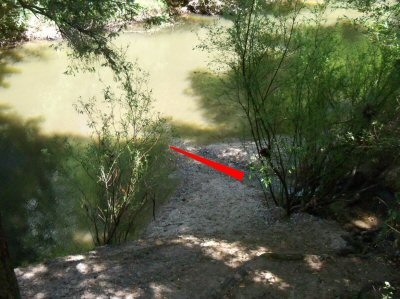
 Red arrow shows where Shingle Mill Creek flows into the San Lorenzo River. Photo by John Pilge, Spring 2011. South of Felton. Starting at 1000 ft elevation, on the eastern slope of Ben Lomond mountain, it flows along Big Trees Road to enter the San Lorenzo River, just south of the bridge at Henry Cowell Redwoods State Park. Typical for a small stream entering a large stream, there can be as many as three different connection points where Shingle Mill Creek flows into the San Lorenzo River.
North of where Shingle Mill Creek flows into the San Lorenzo River there is a stream gauge station to monitor the San Lorenzo River.
History
There was once a shingle mill on that creek.
Businesses
Residential and park area only.
Transportation
Shingle Mill Creek crosses Highway 9 before it enters Henry Cowell Redwoods State Park. Buses travel Highway 9.
Maps
The Mouth of Shingle Mill Creek near Felton can be found on the following USGS map.
| Feature Name | County | State | Latitude | Longitude | Ele(ft) | Map | Entry Date | |
| Shingle Mill Creek | Santa Cruz | CA | 370238N | 1220419W | 226 | Felton | 19-JAN-1981 |
 |
This entry is a seed - a starting point for writing a full entry. You can help the Santa Cruz Wiki by expanding it! Simply click on the "Edit" button. |


